用图解决畅通工程案例与途径查找
代码中需要引入的类方法代码链接:
- 无向图Undigraph
- 深度优先搜索DFS与广度优先搜索BFS
畅通工程-续
介绍
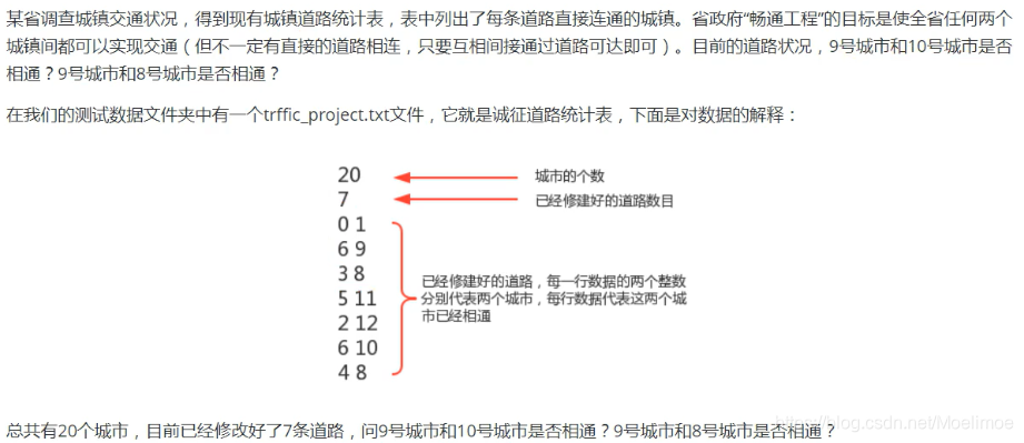
- 案例和之前并查集中实现的一样,但问题略有改动,需要判断9-10城市是否相通,9-8城市是否相通:

使用图解决次案例:
- 创建一个图无向图Undigraph对象 ,表示城市的图;
- 分别调用Undigraph对象的addEdge(0,1),addEdge(6,9),addEdge(3,8),addEdge(5,11),addEdge(2,12),addEdge(6,10),addEdge(4,8) ,表示把已经修好的道路把对应的城市连接起来;
- 通过Undigraph对象和顶点9 ,构建DepthFirstSearch对象或BreadthFirstSearch对象;
- 调用搜索对象的marked(10)方法和marked(8)方法,即可得到9和城市与10号城市以及9号城市与8号市是否相通。
数据集
traffic.txt
20
7
0 1
6 9
3 8
5 11
2 12
6 10
4 8
Python代码实现
from Structure.graph.Undigraph import Undigraph
from Structure.graph.DepthFirstSearch import DepthFirstSearch
from Structure.graph.BreadthFirstSearch import BreadthFirstSearchwith open('../traffic.txt', 'r') as f:total = int(f.readline())UG = Undigraph(total)connected_nums = int(f.readline())for i in range(connected_nums):road = f.readline().split()UG.add_edge(int(road[0]), int(road[1]))city1 = 9city2 = 8city3 = 10print(f"----------------DFS test-----------------------")DFS = DepthFirstSearch(UG, city1)print(f"Is city[{city1}] connected with city[{city2}]? {DFS.is_marked(city2)}")print(f"Is city[{city1}] connected with city[{city3}]? {DFS.is_marked(city3)}")print(f"----------------BFS test-----------------------")BFS = BreadthFirstSearch(UG, city1)print(f"Is city[{city1}] connected with city[{city2}]? {BFS.is_marked(city2)}")print(f"Is city[{city1}] connected with city[{city3}]? {BFS.is_marked(city3)}")
运行结果
----------------DFS test-----------------------
Is city[9] connected with city[8]? False
Is city[9] connected with city[10]? True
----------------BFS test-----------------------
Is city[9] connected with city[8]? False
Is city[9] connected with city[10]? True
9通过6和10相连,9和8不是相通的
traffic.txt:
20
7
0 1
6 9
3 8
5 11
2 12
6 10
4 8
图的路径查找
引入
- 在实际生活中,地图是我们经常使用的一种工具,通常我们会用它进行导航,输入一个出发城市,输入-个目的地城市,就可以把路线规划好,而在规划好的这个路线上,会路过很多中间的城市。这类问题翻译成专业问题就是:从s顶点到顶点是否存在一条路径 ?如果存在,请找出这条路径。
 在这里我们使用的是无向图,只找出一条能够连通的道路即可,后续学习了加权路径之后在寻找指定的路径
实现步骤
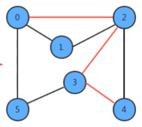
- 我们实现路径查找,最基本的操作还是遍历或搜索图,所以,我们的实现暂且基于深度优先搜索来完成。其搜索的过程是比较简单的。我们添加了edgeTo[]整型数组,这个整型数组会记录从每个顶点回到起点s的路径。如果我们把顶点设定为0 ,那么它的搜索可以表示为下图:
属性与方法设计
- UD 接收传入的无向图
- start 接收传入的值,作为搜索的起点
- marked 标记是否已遍历
- edgeTo 是一个列表,索引代表顶点,值代表当前要搜索的路径中,从起点到索引对应顶点的最后一条边,是路径实现的核心属性
- dfs() 深度优先遍历图的顶点
- has_path_to(v) 获取从顶点开始是否已经遍历过该传入的顶点
- path_to(v) 获取从起点到达所传入的顶点的DFS路径
DFS.txt:
6
8
0 2
0 1
2 1
2 3
2 4
3 5
3 4
0 5
Python代码实现
from Structure.graph.Undigraph import Undigraphclass DepthFirstSearch:def __init__(self, graph, start):self.UD = graphself.start = startself.marked = [False for _ in range(self.UD.vertex)]self.edgeTo = [None for _ in range(self.UD.vertex)]self.dfs(start)def dfs(self, s):self.marked[s] = Trueedges = self.UD.get_edges_of(s)for e in edges:if not self.marked[e]:self.edgeTo[e] = sself.dfs(e)def has_path_to(self, v):return self.marked[v]def path_to(self, v):if not self.has_path_to(v):returnpath = [v]while self.edgeTo[v] != self.start:v = self.edgeTo[v]path.insert(0, v)path.insert(0, self.start)return pathif __name__ == '__main__':with open('../DFP.txt', 'r') as f:vertices = int(f.readline())UG = Undigraph(vertices)nums = int(f.readline())for i in range(nums):x, y = f.readline().split()UG.add_edge(int(x), int(y))DFP = DepthFirstSearch(UG, 0)print(DFP.path_to(5))
运行结果
[0, 2, 3, 5]
顺序不是唯一,跟建立边的顺序,以及设置的优先顺序也有关系,后续会学习到加了权重的边的图,则可以解决最短路径问题,引入的代码地址请回到顶部参考

 empty() in function cv::CascadeClassifier)
)


简介:定义+ 感知机+历史)


![[已解决]fdfs-client-py==1.2.6安装失败](http://pic.xiahunao.cn/[已解决]fdfs-client-py==1.2.6安装失败)
